Wednesday, February 26, 2014

Over the crest

There is a poetry to mountain crests, where the world shifts and the other side comes into view. It is often unexpected, sometimes you stop and sometimes you don't. Sometimes you find what you are looking for and sometimes you don't, but you always find something different. The Chiricahua Mountains are one of those places. I've always revolved around the west slope, having worked for years around Chiricahua National Monument and on ranches and all across the Sulphur Springs valley in southeastern Arizona. It was always the massive arc of the whole range, north to south on the horizon, but always on the eastern horizon. So I took a drive and went looking for something that was supposed to be gone. Then I looked over the mountain range to the over side and found an unexpected window to the future.

The entire crest, from the usual west side. February 2012

Into the heart of the Chiricahuas, the view from the crest southeast. 


What I went looking for, Limosella pubiflora. 14x 
My point in going to the Chiricahua mountains was to look for a plant that I happened to look down and see. It was during a meeting about landscape scale restoration in the borderlands on a site visit to a restored area. I'd been having this conversation with a friend a few weeks prior about this genus Limosella and the thought immediately popped into my head. I snapped a photo and went home and figured out I seen Limosella pubiflora, the Chiricahua mudwort. The type collection (the first collection of a species) was made in Cave Canyon in 1928. But all the habitat for that species had been destroyed when the water was developed in the canyon. So the type locality was known extirpated. That collection is in the US National Herbarium and when examined online looked like what I had seen. But with aquatic species it is hard because they shrivel up and don't quite look like the brilliant little white flower in the landscape. All totaled there were six collections made, the last in 1997. These collections were made in the south and east of the mountain range.

Cave Canyon, the type locality, somewhere in there.

But I was in Turkey Creek, which is on the west side of the mountain. The plot thickened. I was also at the foot of a creek that had seen twenty years of restoration work, with thousands of low rock trincheras built across the stream bed of the entire canyon I was standing in, looking down at Limosella pubiflora. The cows were excluded and there in the delicate fine silty soil at the edge of the 1 cm deep water was this plant that was supposed to be gone. So I went back to collect and confirm that exactly it was what I saw. We shall see. 

It's a complicated story this mudwort. It turns out that the type collection from 1928 was the only specimen that determined the description as a new species. The pubescence of the inner corolla parts is utterly different from the similar Limosella acaulis and Limosella aquatica. There still no resolution of this question as there's been no genetics done on the species. If it is something different it is an incredibly threatened species, given the apparently narrow range of its habitat and the systemic risk of climate change in an already arid landscape. Curious.  
 
The full Limosella pubiflora, the Chiricahua mudwort
The habitat. Pay attention to the trinchera upstream. Twenty years of restoration works.

The Cave Creek sunrise.
Sometimes we find what we've been looking for, sometimes we find the unexpected. I'm glad I looked over the crest. The pictures below illustrate the Chiricahuas are a mountain range in the midst of a great reorganization. In summer 2011, the Horseshoe Two fire burned 223,000+ acres, it started in Cave Creek and burned around the mountain for the next few months. I witnessed the fire first hand in the months immediately after working on NPS lands, stepping into devastated black landscapes. But even there we saw life. The brilliant white of Mexican lilies or Milla biflora set against the scorch was remarkable. 

Contemplating how to measure the black. Late summer 2011

When I went to look over the crest, I saw an intensity of the fire on the high elevation landscape along the crest only as breathtaking as the narrow margin in which something torched and trees right nearby went completely untouched. Sorting through the complex interaction of intentionally set back fires, the struggle to control the fire was indistinguishable now from the landscape in the midst of great change.  Yet the entire landscape was an even more complex one than before. Certain areas will never be the same and new ecological communities are already repopulating those niches left unfilled in the landscape. Oaks replace pines and the pines and spruces and high elevation species move upslope. There is not a long way to go for many of the species on these islands.

And Rustler Park burned.
The burnt summit.

Cochise stares out, Cochise Head from Barfoot lookout, north.

The crest offers views. It offers windows to other worlds. I think I saw one in which fires get a little out of hand. It is one where things are changing and fast.


Tuesday, February 4, 2014

The Winter Drive


Long drives always feel like dreaming. You float along on the endless cushion of the road through the complex landscape, through the hills, the canyons, the trees, the openness. On the Colorado Plateau, it is always the quality of being held up right to the sun, as though examined beneath the massive dome of sky. This was a 1600 mile loop up around the entire Plateau in a week, to attend a meeting in Utah which was essentially just a good excuse to go exploring. The Plateau is this mythic landscape, with rock and views that could easily be described in the language of fantasy. It is a deeply affecting place that helps keep things in perspective.

 These are a few images from out there.  


The road behind me
Houserock Valley, Kaibab Plateau, Arizona
Looking down the Paria, Grand Staircase Escalante National Monument, Utah
Into the Paria

Up the Paria, Utah
Right...
The Freeway goes where?

Monument Basin, Canyonlands
The Henrys with their Heads in the Clouds, Utah

Seeing Mesa Arch
Seeing Beyond

On the Road to the Needles Overlook

The overlook, a 1000 square mile view

On the point


On the corner of WTF

The coming Storm

The Storm, Monument Valley
The Storm lifts


Back home in the Borderlands
Long drives offer a lot of time alone with your mind, tangling with the ever present now. There's the now, now, and now. The Dalai Lama once wrote "there are only two days you can do nothing about, yesterday and tomorrow."

Tuesday, August 27, 2013

The Moods of Baboquivari

There are moments of awakening when we linger in the dream world and the last traces of the dream cling to our minds like water sliding down a rock. I often try to loiter there. Its lasts only a fleeting minute and my heart aches for that moment throughout the day. But on days when I wander off into the field, the dream world pursues me, as though suggesting all of this is a dream. There in the field I stare at the world in its wondrous manifestations, figuring out plants in all their magical forms, with dreams on subtle wings and visions of mountains and light. 

These are the magical visions I saw in a place called Brown Canyon. It is a southeast trending canyon that's closed to the public and open to the four thousand foot rise of Baboquivari Peak above the canyon bottom. It is part of the Buenos Aires National Wildlife Refuge, a 150,000+ acre refuge that sits along the Mexican border southwest of Tucson and is part of the larger Baboquivari Mountains. I spent four days in the valley collecting data for a vegetation map and got to stay in a house nestled near its heart. The words of John Burroughs stuck with me, "So far as seeing things is an art, it is the art of keeping your eyes and ears open. The art of nature is all in the direction of concealment."


Agave palmeri, Palmer's agave

 
Agave palmeri II, writ large
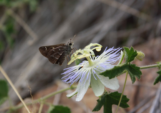
Passiflora foetida, fetid passionflower

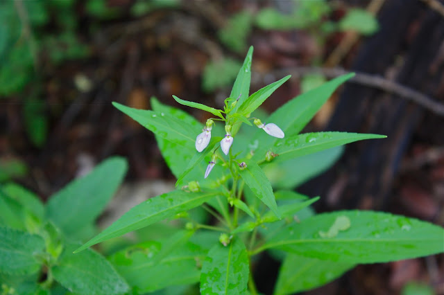
Hybanthus attenuatus, western greenviolet

Cylindropuntia spinosior, walkingstick cholla

 The pods of an Agave palmeri

 The leaf of an Eysenhardtia orthocarpa, the Tahitian kidneywood

Commelina erecta, the whitemouth dayflower

 Echinocereus pectinatus, the rainbow hedgehog
 
An unopened bud of Tecoma stans, the yellow trumpetbush

 
Agave buglandia

One curiosity about spending several days doing nothing but staring at plants is you get to see the most remarkable things. Perhaps it is the slower rhythm, perhaps it is the time spent huddling on the porch as the remnants of a tropical storm plow into the Baboquivari mountains, perhaps you are just paying attention. But these are just some of the many moods of Baboquivari Peak, the most holy and important mountain to the O'odham People.


At the bottom of the picture above you see the small collection of buildings known as the Brown Canyon Environmental Education center. Home for a few days. Here are a few move visions from out there...

 Heading into Jaguar Canyon

 Rainbow agave

The approaching storm. There is nothing quite as frightening as having to walk back down off a slope in the midst of a really violent lightning storm, perils of the job. This photo was about ten minutes before the storm arrived.


Tuesday, August 6, 2013

The Monsoon Grassland I

The monsoon can create convection quickly in August. How is it that we see this? It is water, heat, convection, rain, and life. Why exactly do we not see the planet as an organism we inhabit?

The Convection Sequence, Las Cienegas National Conservation Area

Driving into the Empire Ranch south of Tucson early an August morning. The convection was awake as I left Tucson and I resolved to wander through the Las Cienegas looking for what plants were blooming. Instead, I discovered moisture creating a storm. Twenty minutes elapses between images one to three. I'm fifteen miles from the storm.

 Convection 1

 Convection 2

 Convection 3

Humboldt Canyon, Patagonia Mountains

The photo below is of a canyon under threat because of the 1872 Mining Act. Essentially, arbitrary economic claims on the public good mean we the public do not get to choose whether to have an alternative economy. A law from the 19th century explains the public's right of ownership over mineral resources below the ground. There are alternative economic structures emerging that will support a viable alternative economic model–that model is a restoration economy.


The crest of Aztec Canyon, Patagonia Mountains


This sequence of three images is taken from the crest of Aztec Canyon. It looks northwest toward the Santa Rita Mountains, with Mt. Wrightson in the center. This is the thick monsoon light of moisture as a storm moves in from the northeast. We were digging ocotillo sprouts for restoration research on private land and had walked to the crest of the hill, looking to the northwest and the shifting light as it settled on the near and far ground. The mountains shone. My friend took us to an Agave parviflora plant, a plant whose type locality was collected nearby. the smallest flowered Agave.


The Ocotillo hug the southeast facing slopes, looking south directly into Mexico.


Amsonia grandiflora


From the Whetstone's to the Huachucas


Looking across Las Cienegas NCA, the sky held the immense heaviness of moisture. The rain was coming.